By Jeff Lyons, Partner, AEC Solutions Inc./ Builterra Platform
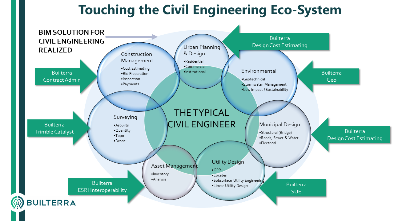
One of the slides I like to show at the start of my presentations is the “Civil Engineering Eco-System” as I understand it from many years working in the CAD design world. From my perspective, each independent business unit or in some cases external sub-contractor lives in their own world of project delivery, data collection and reporting. This “digital eco-system” was conceptualized way back in the beginning when Builterra was being coded from the ground up in 2014.
Our basic scope was to streamline data collection between field and office where Excel, Word and various Access/MySQL databases were used, all disconnected and never integrated. Construction Management or Contract Administration was the low hanging fruit for us to tackle. Integration of other workflows happened organically over the last 5 years where field inspectors and project managers were seeing that if Builterra could work for CA, why not SUE, Geo, Structural and much more.

Builterra Platform
The launch of the Builterra product brand name truly reflects the original vision that our database framework could encompass not only construction contract administration but any data collection workflow within the civil engineering firm. The initial solution was to look at ways of making data collection easy for field staff using mobile phones, then provide a simple project portal for editing data, generating reports and allowing view access to others. The construction contract administration (CA) workflow needed this kind of digital innovation. For years the world of CAD Design, Survey and GIS got all the digital love within the civil engineering practice. With movement towards BIM, Smart Cities, Mobile LiDAR and Drone technology, they continue to bask in the limelight of technology innovation and investment.

Based on our review of how Builterra is being used, we can categorize the users into five industry groups at the current time of this posting:
Builterra Construction Contract Administration (CA)
The use of Builterra for Construction Contract Administration for heavy civil and utility projects is well baked within the Canadian marketplace. We have an end to end solution that stretches from design takeoffs and cost estimating, bid preparation and processing, field inspection, progress payment approval and as-built data reporting. This extensive integration of database components from initial bid items and unit costing to inspection photos and documents provided all the innovation required to organically grow the CA solutions into other associated business units. With over $1.2 billon in approved progress payment reporting over the last 4 years, Builterra has proven itself in the CA field.
The CA group can be further broken into 2 separate groups depending on the owner – Public or Private. We are seeing that the Public Owner is more demanding on project progress reporting, testing and payment approval of contractor invoices with full documentation (Inspection reports, photos and change directives). The Private Owner is less likely to demand daily reporting and more likely depends on weekly site visits to track progress, deficiencies and change orders requested by the contractor. Builterra, was built to handle any owner, project type or inspection reporting demands.

Builterra Municipal (Public Sector Owner)
The introduction of Builterra for construction contract administration meant that standard daily progress reporting and change orders were 100% digitized for the municipal owner to streamline reporting, quantity approvals and progress payment processing.
The expansion of the app was first applied in the simple process of measuring water service connections from the building to the service, and then to the watermain, and then doing a one page report for the owner – for each home. Such a simple task but doing literally hundreds or even thousands on a large watermain rehab project requires a lot of coordination and fulltime data entry staff, drafting staff if you are doing it all without automation. Builterra was quickly applied to the project as the digital data capture and a photo was included with every report along with the water or sewer service properties and tie-ins from the home or other fixed features close to the service.

Fun with AutoCAD Automation
With standard mobile data entry, centralized storage and an excellent API for AutoCAD, the task of automating Water or Sewer Servicing card schematics from data collected from mobile phones was implemented. We also have an AutoCAD server processing behind the scenes, so soon as the service card data is captured, the AutoCAD schematic is processed and added to the report…in real-time, no time or staff required for this very repetitive process.
Builterra Urban Land Development (Private Sector Owner)
The use of Builterra for a private land development engineering firm was actually our very first sale. The development of site plan and subdivision catalogs, historic cost estimating database, bid preparation and email-based bid process management was the early requirement that defined the Builterra CA product. It was not until we introduced inspection that the requirements looked different than traditional municipal infrastructure daily progress reporting and change orders.
The Daily Site Visit, Lot Grading and Servicing – Pre-sod and Post-sod Deficiency Report, Erosion Sediment Control reporting and other very specific deficiency forms for curb, sidewalk, pavement and sewer/water inspections further expanded our solution to fit the Urban Land need.

Need a Photo? Got a Photo?
This was an obvious need for any firm collecting large amounts of photo data. Question: Why are photos still being taken, downloaded to laptops, transferred to network folders, renamed and readied for the humans to "drag n drop", position, caption and save in a disconnected Word doc?

For the all those IT People: ALL Builterra photos and reports can be sync / posted to any cloud document management system like BIM 360 Docs, Projectwise, Onedrive, Dropbox, Sharepoint etc..
Bonus for Designers: Real-time AutoCAD Civil 3D Cost Estimating and Bid Sheet Preparation
Once the CA group starts using Builterra for cost estimating and bid sheet preparation, that same cost data can be accessed in AutoCAD Civil 3D directly. When a quantity takeoff is performed using Builterra Design Connect, bid data is automatically posted to the Builterra bid sheet table and cost estimating is returned back to the Civil 3D designer. This is the only real-time QTO and Cost Estimating system that can actually do this with high accuracy based on combined BIM principals (object properties) and GIS query (project properties). If State, City and County bid data had this level of detail, using model and spatial query, the costs could be narrowed down to location of project, item size, shape, depth, soil types, and even contractor. Owners could provide detailed pricing from concept to detailed design with little effort using this kind of data framework.

Builterra Subsurface Utility
Our very first mobile field inspection forms released were the utility testhole and exiting manhole invert data collection forms. The “test project” was a $350m 12km rapid bus transportation project on the busiest urban street in the City of Toronto. Over 6000 hydrovac excavations and 400 manholes were inspected over a 2 year period. Every Hydrovac Level A testhole was measured and identified with photographic evidence. Every manhole lid was opened, photographed, invert depth measure & pipe diameter captured. The post-merging of GPS survey data using the web portal function to add northing, easting and elevation to every inspection made it possible for accurate map display with an applied utility type theme. This standardized method of managing the data collected from 3 different subsurface utility firms made post processes easy to implement.
The collaboration with the civil engineers doing the road, water, sewer and utility relocation, data collected was made available for viewing and downloading by any project team group. This is the same system used in Contract Administration, just re-configured data collection forms and reports made easy for SUE processes. The success of the project defined how we started thinking differently about Builterra.

Direct import of testhole and manhole data into AutoCAD directly from Builterra made plots in plan view with attributes and projection to Civil 3D profile views easy to code and deliver…all in realtime from the cloud database. This data supported the BIM modelling process using AutoCAD Civil 3D and eventual data import into Autodesk Navisworks and Infraworks.

Builterra Geotechnical
Once the Land Development engineers started using Builterra, the questions about geotechnical data capture started coming. Can we get our boreholes in the map? Can we log and review compaction tests in the areas of engineered fill? Can we get a water level elevation surface quickly from the data?
As you can guess, yes is the answer to all of these questions. The way we configure our mobile forms with looping table data (just like Excel Tabs, Columns and Rows) means that everything about the borehole can be logged into a single inspection record. Soil strata, penetration tests, water levels, moisture tests and cave in elevations are all captured using a mobile device. Post processing using AutoCAD to produce Borehole Logs, Strata Fence Diagrams, Plan Plots, Projection of borehole to Profile Views make this solution accessible to any geotechnical firm and engineer who sub-contracts them for Geotech reporting.

Builterra Structures (Bridge and Culvert, Chambers)
Bridges and culverts are also finally feeling the love from Builterra. With the recent introduction of the Ontario Structure Inspection Manual (OSIM) into the Builterra family of pre-fab configured forms, we can confidently say we are very much the heavy civil infrastructure focused solution for Civil engineers looking to capture data and photos. The OSIM is very well suited to Builterra looping data tables with the requirement to inspection element families and elements with specific quantity measurements based on element type.
For large bridge and culvert inspection projects, pre-loading the Builterra database with bridge ID and map location is just the winning solution when managing the work on many structures. Without the excess cost and learning curve of GIS, any certified bridge inspector can perform the observations and capture photos, markup PDF drawings and details as required for the standard report.

Realizing the Vision
It’s summer 2019 and we are now seeing an organic growth of our solutions within civil engineering firms who have adopted Builterra originally for construction contract administration but have realized it’s value in collecting other data required for unrelated workflows within the same organization.
The expansion of Builterra into other departments means that ANY data collected using cell phones and tablets is completely standardized, centralized and accessible throughout the same organization or external project partners using web browsers.
Without the complication and costs of IT or GIS, all critical contract administration data like progress payments, inspection, testing and photos can be accessed by the entire project team. Expanding the use of Builterra for other groups collecting data, means ANY person with a cell phone can collect ANY data and associated photos with confidence that that same data will find it's way into a Report, Excel Spreadsheet, GIS Table or CAD drawing with very little effort.

As you can see, Builterra is so much more than a "One Trick Pony" that ONLY does State or Provincial DoT Transportation projects, or something mandated by the City/County at 3x time the subscription cost - I hate that when they do that.
We wanted Builterra to be a tool that engineers want to use, at a fair cost. With 80% of our subscriptions being used by the private consultant, with 0% being "mandated" to use it, we feel we have really hit the mark with our user base. If you are ready to get rid of those disconnected spreadsheets and manual data collection, call us and we can help you get started personally, onsite with a 100% chance of success once you have made the decision to go digital!